
Elevation
Capture elevation changes as you move
Obtain precise elevation and slope data with Moasure – the ultimate tool for professionals who need accurate measurements across challenging terrains.
Choose your Moasure

Try it with our 60-day money-back guarantee
How it works
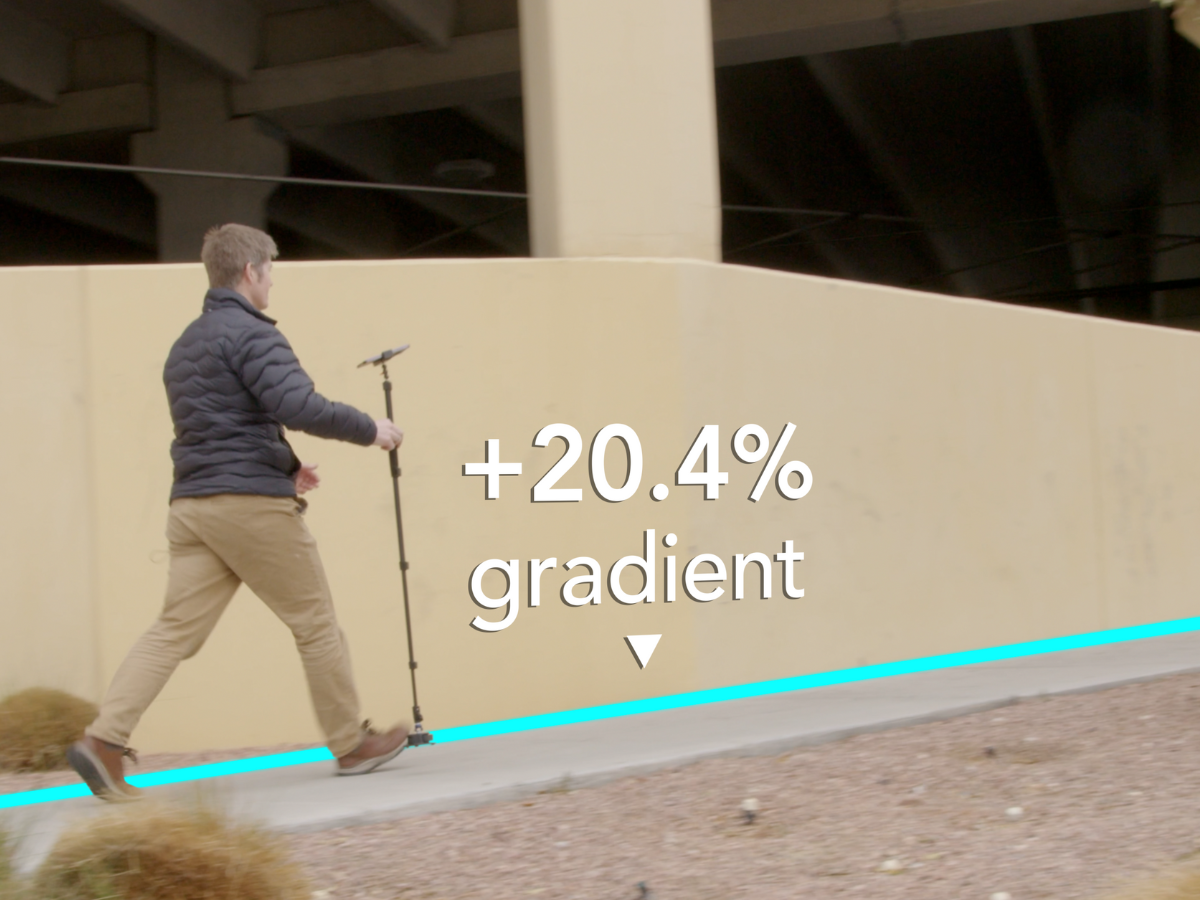
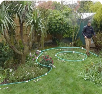
Effortlessly capture elevation changes
Moasure accurately measures elevation changes as you move, calculates grade, and determines rise and run.
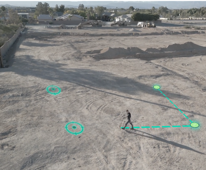
Measure elevation as you move
Moasure’s motion-sensing technology allows you to capture elevation changes across any terrain. Whether you’re working on a sloping landscape, grading a construction site, or assessing drainage requirements, Moasure provides accurate elevation data.

1
1
2
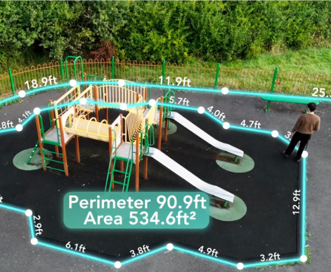
2
Calculate the slope & grade
Moasure simplifies the process of calculating gradients. By capturing multiple elevation points, Moasure instantly calculates slope percentage, rise and run, and the angle between any two points.
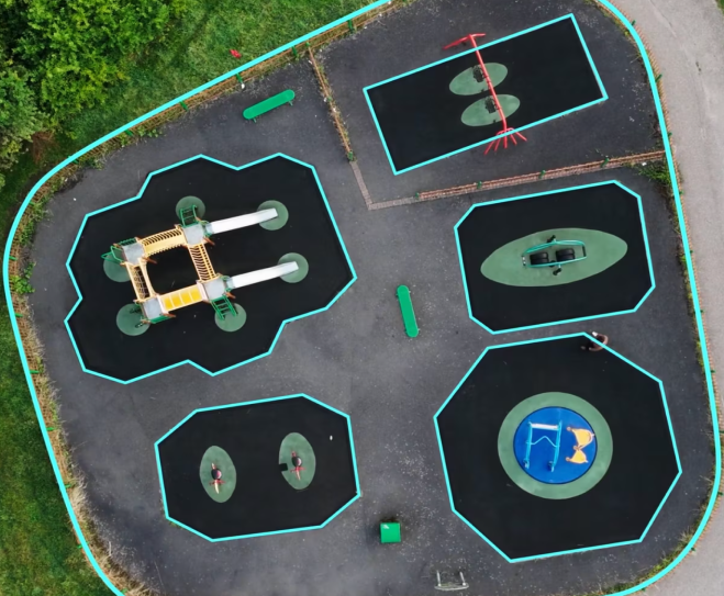
Use the Cross Section tool to visualise elevation
Moasure’s Cross Section tool captures elevation profiles as you walk the site. It’s perfect for visualising slopes and grading, providing the essential data needed for accurate excavation, drainage, or site planning decisions.
3
3
4
4
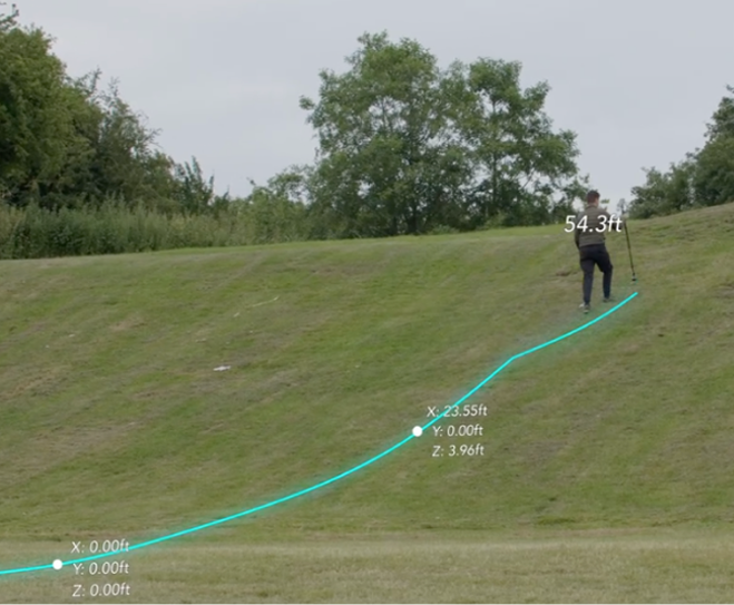
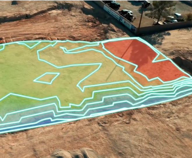
Visualise measurements both in 2D & 3D
Moasure automatically generates 2D and 3D diagrams of your elevation measurements. Show clients or colleagues how the landscape changes, providing a professional view of how slopes or grades will affect the project.
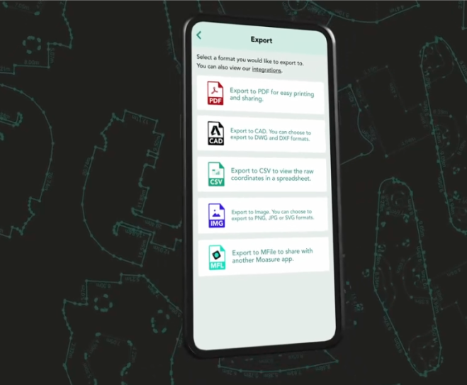
Export your elevation data
When your measurement is complete, export your elevation data directly into your preferred CAD software or as a PDF, CSV, or image file. Moasure integrates seamlessly into your existing workflow, making it easier than ever to share and present accurate elevation details.
5
5


Save time, maximise profits, & eliminate errors
Try Moasure today and experience the savings firsthand
Choose your Moasure

Try it with our 60-day money-back guarantee
The easiest way to measure elevation across any terrain
Watch this short video to see how straightforward it is to use Moasure to measure elevation.
Choose your Moasure
Try it with our 60-day money-back guarantee
Testimonials
Hear real stories from customers using Moasure
Over 100,000 professionals already love using Moasure to quickly measure elevation, saving them thousands of dollars in material ordering each year.
Highly recommend for anyone estimating jobs
"I use Moasure every day, whether for quick elevation measurements or mapping pool decks and fire pits. It’s much faster than the traditional measuring wheel and level, combining tools into one device that fits on my belt."
Presidential Pools
Pools & Gardens
Verified Review
A game changer every contractor needs
"My new Moasure device indicated we were a few inches off in elevation. Initially skeptical, we confirmed it with a laser and found Moasure was accurate. It saved the day and prevented a costly error. For the price, it’s a game changer every contractor needs!"
Mark McDonald
Excavation
Verified Review
Saves us 45–60 minutes on each visit
"We’ve gone from transit levels to Moasure, which captures measurements and elevations in one step and saves them for our design software. This change saves us 45–60 minutes on each initial visit. No more grids and manual entries—just quick points and uploads."
Integrity Hardscape
Hardscaping
Verified Review
This is a complete game changer!
"I have been able to not only get areas with ease, but elevation changes, slopes and more! It has revolutionised the way I do things! No more tape measure and wheel!"
Richard Watkins
Contractor
Verified Review
Moasure saves time and money
"I love that I can get out of my truck and shoot elevations for determining how much dirt needs to be excavated. We used to have to set up our laser, hoping it was placed right to read elevations. Moasure saves time and money."
Millstone Custom Homes
Construction
Verified Review
Moasure is worth the investment
"Moasure is valuable for acquiring site data on measurements, areas, and elevations. It’s simple to use and stores data for later. We export it to our design team, enhancing project accuracy. Highly recommend."
Leanard Design
Architecture & contracting
Verified Review
Choose your Moasure
Try it with our 60-day money-back guarantee
Why Moasure outperforms traditional tools for elevation
Moasure measures elevation seamlessly, delivering faster, more consistent results across varied terrains.
Works on uneven or sloped terrain
Calculates true surface area
Automatically measures elevation as you move
Works without line of sight
Speed of use over long distances
Ability to measure irregular shapes

Very fast
Measuring
wheel
Fast
Slow
Laser
level
Very slow
Tape
measure
Choose your Moasure
Try it with our 60-day money-back guarantee
Frequently asked questions
Everything you need to know about using Moasure to measure elevation.
Moasure 2 PRO has an elevation measurement error of ±0.3%, offering up to 99.7% accuracy with great user technique. This means that if you measure a 100 meters elevation change for example, the value will range from 99.7m to 100.3m.
In comparison, Moasure 2 has an elevation measurement error of ±0.5%, providing up to 99.5% accuracy. For a 100 meters elevation change, this would give a measurement range of 99.5m to 100.5m.
Choosing the right Moasure device for you will depend on the level of accuracy you require for your projects.
Our X2 and X2-PRO Inertial Sensor Engines utilise accelerometers, gyroscopes, and a second-generation proprietary algorithm to track the device's movement in 3D. The Moasure app then records a point with x, y, and z values relative to the starting point.
Yes, Moasure captures x, y & z data for each point you capture. All of this data can then be exported to DXF or DWG, ready to use across a wide range of CAD applications.
You can also use Moasure to generate detailed, scaled PDFs, edit data with CSV exports, or visualise measurements using PNG, JPG and SVG formats.
Yes, it's easy to switch between metric and imperial units in the Moasure app. You can adjust this in the app settings at any time.
CHOOSE YOUR MOASURE RISK-FREE
100% money-back guarantee
Every Moasure device is tested to ensure it meets our accuracy and precision standards.
Plus, every order comes with a 60-day money-back guarantee as standard.
Thousands of professionals have transformed their workflow with Moasure.
Give it a try and you’ll never look back.

Choose your Moasure
Try it with our 60-day money-back guarantee
MOASURE FEATURES
See what else Moasure can do
With a range of professional features available, learn more about each one here.
Measure & draw simultaneously
Generate accurate dimensioned drawings while you move.
Calculate areas & perimeters
Automatically calculate the square footage and perimeter of a measured area.
Add multiple layers
Capture multiple areas in one seamless measurement.
Calculate elevation as you move
Measure elevation, determine grade, calculate rise & run.
Measure 3D terrain & volume
Generate 3D terrain maps, calculate true surface area, volume, and contour lines.
Export measurements
Share measurements with clients, colleagues or your favorite design software.
Exclusive to Moasure 2 PRO
Layout mode
Stake out points based on entered coordinates.
Coming Soon
Floor plans
Instantly generate comprehensive floor plans.
New device coming soon.